1. Introduction
Overview of topics covered
Pedestrian accessibility is a measure of how easy it is to walk to the places people want to go. Land use, network design, and site design are the main components. In section two the physical elements which together provide pedestrian access are delineated. Guidelines used by planners, governments and academics range from the specific to the vague. In order to assess our current level of pedestrian access, and the nature of any changes made, it is necessary to quantify pedestrian accessibility. Section three describes various methods, which vary in the extent to which they incorporate perception, and in scale. Section four explores the discrepancy between wide-spread acceptance of the concepts of pedestrian-friendly design, and the relative paucity of such design. Section five first looks at process: what does it take to provide for pedestrian access in our multi-jurisdictional cities, where planners have not historically been the strongest political force? Generalizations and case studies are offered. Section six looks at attempts to measure the impacts of pedestrian access on travel behavior; for example, can providing pedestrian access decrease VMT? Section seven outlines some of the other, non-quantifiable, benefits which have been offered in support of pedestrian access, such as increase in social capital and meeting existing demand.
A note on semantics
The terms pedestrian accessibility, pedestrian-friendly or -oriented design, walkability, transit-oriented development, and local versus regional accessibility, are some examples of terms which have been defined differently by different authors. There is a significant amount of overlap. Pedestrian accessibility or walkability, requires both supportive land use patterns and also pedestrian-friendly or -oriented design. Transit-oriented design is pedestrian accessibility, with an emphasis on the land use components, and the addition of transit accessibility. Accessibility can be considered at various scales. Site accessibility suggests a narrow focus, and neighborhood accessibility a more broad focus, considering more land use factors.
2. Definition and design guidelines
What we mean by pedestrian accessibility
Table one outlines some of the factors in pedestrian accessibility. It is not a comprehensive list, rather an attempt to select the most salient issues raised in the literature. Land use is found twice on the list because it needs to be considered at two different scales. The density and mix of uses of a neighborhood will determine if most residences are within walking distance of their destinations. Land use at the site level is considered in the case of commercial or employment centers. Again, distance between, and variety of, uses is relevant. Ewing (1997) defines destination accessibility as how easy it is to travel between destinations.
| LAND USE: | DISTANCE (DENSITY, LAND USE MIX), REAL AND PERCEIVED | |
| NETWORK: | SIDEWALK/ PEDESTRIAN WAY | |
| EXISTANCE | ||
| CONTINUITY | ||
| CONNECTIVITY: DIRECTNESS OF ROUTE | ||
| QUALITY & MAINTENENCE (SURFACE, OBSTRUCTIONS) | ||
| STREET-CROSSING EASE | ||
| SAFETY | ||
| SEPARATION FROM , VOLUME, SPEED & TYPE OF VEHICLES, CONFLICT POINTS | ||
| PERCEIVED | ||
| ENVIRONMENT | ||
| SECURITY (FROM CRIME), REAL AND PERCEIVED | ||
| LANDSCAPING, ASTHETICS, LIGHTING, VISIBILITY | ||
| SOCIAL | ||
| COMMERCIAL (E.G. SET-BACKS AND TYPES OF BUSINESS) | ||
| TOPOGRAPHY, WEATHER/PROTECTION FROM | ||
| PUBLIC SPACE | ||
| SITE DESIGN: | SCALE | |
| ENTRANCE WITH RESPECT TO PED NETWORK | ||
| DISTANCE TO | ||
| ROUTE PROVIDED/ BARRIERS (E.G. PARKING LOT) | ||
| LAND USE (DENSITY & MIX): "DESTINATION ACCESSIBILITY" | ||
There is a wide array of literature that advises on how to achieve pedestrian accessibility. Suggestions range from the vague to the highly specific. Government pedestrian design guides are lengthy documents, typically focusing on engineering minutiae of network, and sometimes site, design. Many states outline the responsibilities and power of localities. Oregon’s bicycle and pedestrian plan requires that one percent of the state transportation funds given to local governments be spent on pedestrian or bicycle facilities. It also gives localities important powers such as the power to build sidewalks and tax the beneficiaries, or the power to use school transportation funds to build pedestrian facilities off campus if that will reduce transportation costs and increase safety. Oregon’s 1991 transportation planning rule includes stipulations for site access. A government agency can be extremely specific in its requirements on the project level, including requirements on all three of the areas listed in table one.
Design books consider site design, along with atmosphere and aesthetics of the network and public spaces. Via the Americans with Disabilities Act, the federal government mandates a variety of network and design modifications, many of which benefit the mobile elderly and other pedestrians. USDOT’s Pedestrian Facilities Users Guide-Providing Safety and Mobility (2002) recognizes the importance of land use patterns and pedestrian environment in mode decisions, and the value of integrating land use and transportation planning. The majority of the report, however, focuses on safety (including a section on traffic calming), as this is the topic that USDOT knows best, and the area in which it has influence.
Ewing (1997) offers the following four guidelines for planning for pedestrian accessibility: keep trips short, safe, and interesting, and keep traffic slow. He suggests that pedestrian trips are kept interesting by designing for complexity and visual enclosure, and that roads must have a sense of place, be of human scale, and rich in human activity.
A recurring theme in the literature is a need to recognize pedestrian and auto access as equally important when designing shared facilities such as intersections and parking lots. The least pedestrian accessible places have been designed to give priority to the auto.
3. Measuring pedestrian accessibility
"The key is to measure accessibility in terms that matter to people in their assessment of the options available to them...For the transportation component of accessibility, this means knowing something about what characteristics of different modes of travel matter to people." (Handy & Clifton, 2000)
Pedestrian accessibility includes factors which range from highly subjective to relatively objective, which poses a measurement problem. Some measurement attempts have focused on the objective factors, and others have attempted to consider these factors as experienced by users. The use of the word objective does not imply that no judgment is involved. The decision to include a given factor in a measurement, and the method used to measure that factor are clearly judgment processes. As used here, subjective and objective are not so much opposites as relative terms. For example, walking distance is a more objective measure than pleasantness of walking environment. One thing to note about these various measurement attempts is the variety of scales, which range from facility to neighborhood.
3.1 Measuring the objective factors.
The federal Highway Capacity Manual offers a definition of the pedestrian level of service (LOS) similar to the vehicular definition. Speed and volume are the important elements, so a wide and empty sidewalk is optimal. One of the problems with this definition is that the scale is too small; we could theoretically be considering one linear foot. The aggregate experience of the entire walking trip, or at least a significant part of it, needs to be summarized in our measurement. Another problem with the measure is that it ignores the experience of the pedestrian. For most pedestrians, flow rate is a lower priority then, say, likelihood of getting mugged. The fact that places where people walk the most will rate poorly on this scale is the first indication that it is inadequate.
Not all measures of the objective factors are so devoid of an understanding of the pedestrian experience. McLeod (2000) outlines Florida’s approach which includes four weighted variables: lateral separation, motorized vehicle volumes, motorized vehicle speeds, and large truck volumes. Lateral separation includes the presence of a sidewalk and is weighted most heavily. Several other approaches are outlined below.
The walkable catchment of a location is a measure of network connectivity, a factor in walkability. One method of measurement starts with a point of interest, for example a transit stop. A quarter mile radius is drawn around this point on a map, and actual walking route length is measured for each route leaving the point. The final number is the fraction of the area within the circle which is served by routes which are actually a quarter mile. Sixty percent is offered as an optimistic score. A subjective measure is introduced as routes which are deemed unsuitable (e.g. unsafe) can be excluded from the analysis. This method does not allow us to rate poor routes which some people must use if they are to walk, among other limitations. It is a simple method which allows for a quick evaluation of the route connectivity to a given site. (STPP, 1999)
Aultman-Hall et al. (1997) used GIS to compare trip lengths for all residences in three different neighborhood designs. The first design is the one that the developer had proposed, the second was the same as the first with pedestrian walkways added, and the third was a completely new design, which included higher residential density, more gridded streets, and more integrated land use. The percentage of residents within walking distance (400 m) of important destinations was compared. For example, the percentage of residents within walking distance of the school was 25% with design one, 34% for design two, and 67% for design three. The third design was the result of an assignment in which students were asked to meet several sustainability goals, including reduced run-off, reduction of per capita utilities cost, increase in open space, and viability of non-auto choices. One advantage of the approach of applying GIS to plans in the design stage, is that it can be used in the analysis stage of a project, and by dint of its objective emphasis, may lend itself to incorporation in cost-benefit type analyses.
Hess et al. (1999) compared 12 neighborhoods in the Puget Sound area with similar demographics and land use, but very different network and site pedestrian accessibility. Unlike those previously mentioned, this study combines measures of several different accessibility factors. Their independent variables include: block size, miles of sidewalk available, sidewalk completeness, distance between pedestrian entry points at commercial sites, and route length. Notable contrasts between accessible and non-accessible areas are pointed out by the Hess article. The area of a block in the suburban, non-accessible, areas was on average 12 times larger than in the accessible counter parts. Route length was significantly affected by fences around housing developments and the limited pedestrian entry points of some sites.
3.2 Measuring both subjective and objective factors
"Crucial to determining the acceptable distance in a given situation is not only the actual physical distance, but also to a great extent the experienced distance." (Gehl 1987)
Untermann (1984) suggests that acceptable walking distances can be doubled with concomitant improvements in pedestrian atmosphere. A recurring, though not universal, theme in these studies is the active participation of residents in the assessment. This envisions not just a new method of evaluation, but also an inclusionary vision of what planning can be.
Khisty (1994) suggests that the quantitative pedestrian LOS outlined in the Highway Capacity Manual should be supplemented by a qualitative LOS. He suggests a method in which each route is individually evaluated by a committee of users who decide which performance measures (PM) will be considered. Relative weights are determined by the group and users are surveyed on satisfaction with each PM. In the example provided, the PM’s in order of decreasing importance were: security, safety, comfort, convenience, attractiveness, system coherence and system continuity. The percent of users which found a given PM satisfactory is combined with the weighting to arrive at an A-F rating. While government officials may find the level of public involvement prohibitive, Khisty sites it as an attribute. Truly this rating system reflects the experience of users and the public gains respect for the process via their involvement. The route specificity limits applicability at the neighborhood scale, though it would be possible to modify the method.
The pedestrian environmental factor (PEF) was devised by 1000 Friends of Oregon to rate the pedestrian environment. (Parsons Brinckerhoff Quade and Douglas, Inc. 1993) It differs from LOS in its scale: it looks at an entire neighborhood, and it’s focus is on the network. PEF is influenced by four factors. Each is field rated by several individuals on a scale from one to three and scores are averaged among raters. The final PEF score of a zone can range from 4-12. The four factors are network connectivity and continuity, ease of street crossing and topography.
Handy and Clifton (2000) begin with the basic definition of accessibility as the attractiveness of a destination, lessened by the impedance as measured by distance, time and cost. They add several considerations to both the destination and the transportation components. The attractiveness measure considers factors that relate to the activity itself, but also includes the design of the site of the activity, for example the density, land use mix, parking, atmosphere, and landscape of the site. The transportation factor should also consider LOS, terminal factors and comfort factors. LOS includes volumes/crowding, signalization, directness of route, continuity of route, signage, facility widths, shelter and benches. Terminal factors include intermodal connections and terminal design. Comfort factors include traffic speed, traffic volume, pavement condition, lighting, weather, shade, scenery, crime/police presence, cleanliness, conflicts with other modes, and other users. A measurement paradigm is offered in which the first step is to identify the factors that matter to residents and then secondly measure those factors, in some cases using GIS to measure. They suggest that the labor intensive data collection required to create an electronic database of the pedestrian environment calls for involving the community in data collection. They suggest that it is not only possible, but desirable, to train residents to use mapping programs. The visualization tools offered help residents to understand the implications of the collected data, and the ways in which their experience might color their data collection is a bonus, as it is their perceptions about the barriers to walking that most need to be addressed.
It is perhaps a sign of the times that a federal agency with highway in its name has created a walkability checklist, which neighborhood residents might use to identify shortcomings in their pedestrian environment. (NHTSA, undated) It is a comprehensive checklist in a user friendly format. The user rates each of 5 factors on a scale from one to six, with a resultant possible score of five to 30. The first question asks if there is enough room to walk, and elements considered include sidewalk presence, surface, continuity and obstruction. The second question asks how easy it is to cross the street. Elements considered include signal presence and timing, view obstruction, and road width. The third factor asks if drivers behaved well and the fourth asked if it was easy to follow the safety rules. The final factor is the pleasantness which includes safety, landscaping, lighting, even "scary dogs".
Burden, of Walkable Communities Inc., makes a living of helping communities evaluate and improve their walkability. One measure he suggests is the step-out test. (Burden, 2001) As a person initiates crossing at an unsignalized cross walk, how do motorists respond? He suggests that driver courtesy declines steadily as speeds exceed 25 mph. He offers to conduct a walkable audit of the community, in which he is joined by a diverse group of community members including police, city staff, emergency providers, business leaders, and developers, for a walk through the neighborhood. (Walkable Communities Inc., 2001) The group rates the sidewalk width and condition, street crossings, connectivity to parking, on-street and off-street parking, screening, tree canopy, building placement, restorations, and housing type and mix.
4. Guideline-implementation disconnect
There are far more good guidelines than there are good places to walk. The reasons for this include jurisdictional issues, durability of the built environment, and developer risk-aversion. Cervero (1993) found that about 20% of surveyed transit agencies have guidelines about transit-oriented development, but that most transit agencies have little or no land use power. His Chicago case study is a good example. The MPO has an excellent set of guidelines regarding pedestrian accessibility of transit stations, but the cities don't enforce the guidelines. Developers don't follow them, citing risk-aversion. Cervero surmises that many planning agencies feel impotent to break the cycle of land use patterns and exclusionary design which perpetuate each other.
In several other examples cited, guidelines placed requirements on future development. After several years of weak real estate and construction markets, there was little evidence of implementation, as there had been little new large-scale developments. This method can only bring about change at the rate of turn over of the built environment plus infill.
Arambula (2002) reminds us that developers are interested in certainty: they need to know that TOD is an investment which will provide a financial return. He suggests providing this through public investment in pedestrian amenities, and building codes which offer reassurances about what neighboring land uses might be. Whatever guidelines or action plans a city may devise, generally a developer has to see the potential for profit, or no implementation will happen.
5. Implementation
How pedestrian accessibility gets implemented and some examples
5.1 Process
Some generalizations from successful projects
Several case studies are offered below. There are certain commonalties that these stories share. Cities must have supportive codes and zoning which require, or at least allow for, the changes required. Often several different agencies work together. Often there is a single individual or a grassroots group which is particularly dedicated to the project. Visual aides are used to help planners and residents envision the changes. Providing pedestrian access is not a one time project. It requires a multifaceted approach and must influence virtually all aspects of planning and development. Programs which target new growth will only see significant implementation when the economy is supportive of development. One large developer may be an easier target for cities, as it is more likely than small developers to have the resources to take risks, and once they are on board, the impact will be on a useful scale- an entire community. If a clear market demand does not exist, developers’ fears need to be allayed, or their financial risks offset. Retrofitting an existing development by adding site or network accessibility can only be expected to be successful if the land use patterns are also supportive.
Moudon (2001) has developed a GIS tool for localities to identify the locations that have supportive land use, so that network and site design improvements can be targeted to places they are likely to have an impact. ArcView is used to isolate residential density data from census data. Aerial photos are used to identify land use. Several queries are used to identify development clusters. This approach is based on the thesis that there are suburban areas with sufficient density and land use mix to support increased walking. The tool is offered so that limited resources for pedestrian amenities can be targeted to locations where they might be most effective. Moudon states that 20% of the Puget Sound suburban population lives in such clusters, and that increasing route directness and sidewalks can be expected to increase walking. She suggests that the reason that previous attempts to use GIS to identify such areas have failed is their reliance on traffic analysis zones (TAZ) as opposed to census block. The size of a TAZ is about twice the size of the upper threshold she sets for a cluster (500 acres), and since the boundaries of a TAZ are typically the very arterials around which clusters develop, they frequently split such clusters, and thereby fail to recognize them.
5.2 Case studies
A New York Times article (Egan, 2001) chronicles Los Angeles' recent turn towards higher density. A combination of city initiatives, market forces, and a demographic shift have created the demand for pedestrian-friendly development in some areas. Changes in city code include elimination of parking requirements for new apartments. Planners and developers both cite market demand as the driving force behind the new developments. It is suggested that congestion, the cost of low-density housing, and a lack of middle income home-buyers have contributed to this. Also cited is the changing ethnic composition of the city. "The starter-home market for upwardly mobile Latinos is bottomless. These are people who want a home with new countertops and a nice entertainment room, but they also want to be close to the old church and family." (Fulton in Egan) Our cities are increasingly people of color. In some cases, these populations may be creating a market demand for pedestrian-friendly development because of the social consequences. The very fact that Los Angeles might be cited in a paper on pedestrian accessibility clarifies the physical and temporal scales which we are considering.
In Toronto, providing pedestrian access is one part of a multifaceted approach to reducing auto use. (Koropeski et al., 1998) Toronto has six miles of underground pedestrian pathways connecting the CBD, with connections to major transportation, office, and commercial destinations, but remains committed to also maintaining a positive pedestrian atmosphere on surface streets. A notable feature is the requirement that new large construction projects be connected to the pedestrian network. The city's planners have an eye to the future needs of pedestrians, for example by developing pedestrian safety programs aimed at the aging population. Toronto’s high density enables these network features to impact behavior. The auto mode split into downtown is 35% during peak hours.
Cervero (1993) conducted a lengthy study on TOD for the federal government. Some of the case studies presented are instructive. In the case of a development project in San Diego county, several factors contributed to success. Otay ranch is a 23,000 acre mixed-use development with a single developer in an unincorporated area. Cross-jurisdictional cooperation included two near-by cities, the county and the MPO. This coalition was formed early enough in the design phase that citizen participation groups had the chance to form and offer input during plan formation. TOD luminaries such as Calthorpe and others prepared visual aides which helped developers and the public visualize what a pedestrian-friendly environment looks like. The final project was 12 village clusters designed on Calthorpe’s pedestrian pocket model, with an average density of 18 units per acre.
In the San Francisco bay area a wide range of agencies have policies which encourage or require pedestrian amenities. In some cases this has resulted in little-used sidewalks provided in places where the land use is not supportive. But two shopping malls in the island city of Alameda have raised pedestrian and transit-riding shares to significantly higher than the county or city average, after instituting design changes. One shopping center incorporated transit-oriented design, but due do poor bus service, there was no significant increase in transit use. However, 16% of the work force arrives by foot or bicycle, made possible by surrounding high levels of residential density. The limited success of similar measures in sprawling suburban Contra-Costa county are a fitting contrast. Low-density office parks surrounded by low-density housing have seen negligible effects from adding pedestrian amenities.
In Snohomish county in the Seattle area, the county transportation agency's president has gone to great lengths to popularize neotraditional ideas, which provide for local pedestrian accessibility. Some of his tactics included local and national presentations, a video and slide show for developers and planners, and regular contact with this group. Sno-Trans' publications, which include illustrations and graphics, became a well-known resource, and have been incorporated into the plans of many localities in Washington. The agency's 1989 plan calls for increased density, land use balance, and pedestrian and bicycle networks that connect activity centers. Despite all of this results have been mixed. Two retrofitted shopping centers saw little change in modal split. But a newly constructed mixed-use development has high transit and pedestrian mode splits. This example illuminates what an uphill battle it is to change the accessibility of an existing site. Site design can be improved, but low surrounding residential densities will provide an insurmountable barrier.
Gresham, OR has used a multifaceted approach to improve the pedestrian atmosphere. The Ped-to-MAX program addressed the environment surrounding light rail stations. (Ocken, 1999) Street trees were added, pedestrian crosswalks were texturized, sidewalks were improved and bulbouts added at crosswalks. A tax incentive program has been successful in luring transit-oriented development. A 10 year property tax exemption is awarded to developers who meet a list of stringent design and density guidelines, including a range of income levels for housing, and public services such as a daycare or open space. The boulevard program improves the pedestrian environment on the wide arterials. There has been a marked improvement in the pedestrian environment in the treated areas, which contrasts sharply with the poor pedestrian environment of nearby areas. These programs are currently being implemented and the impacts on behavior are not yet known. Significant barriers exist, such as wide, heavily traveled arterials, and in some places large block size. Cultural inertia and durability of the build environment are also relevant. The Rockwood area, recently annexed by Gresham, has a high number of pedestrians even though the walking atmosphere is quite poor. The potential to improve safety and quality of life here is significant. Gresham’s multifaceted approach, with strong leadership from city planners, shows great promise. Ocken states that Oregon’s 1991 transportation planning rule, with its mandates for limited building set-back, has been a big help in the city’s attempts to provide for pedestrian access.
In summary, the methods for achieving pedestrian accessibility is as varied as the places they target. A multifaceted approach is essential.
6. Impact of pedestrian accessibility on travel behavior
Does providing for pedestrian accessibility have any impact on behavior? When it doesn’t, why not?
6.1 Theoretical
As mentioned in section three, Autman-Hall et al. used GIS to compare route lengths of various proposed designs. They found that changes in network design (griddedness), land use mix, and density created a situation where more residents were within walking distance of destinations. Robinson et al. (1980) created in-depth surveys to gauge stated preferences. For example, when a perfectly pedestrian accessible environment was described, respondents reported that such an environment would double their work trips by foot, (14% to 30% of work trips). Even more people said they would walk to work (34% of trips) in the compact land use and pedestrian facilities scenario. These surveys were taken in several different areas, which varied in their pedestrian accessibility. It was the places with the best pre-existing pedestrian facilities that reported the highest rates of potential mode change. Perhaps people living in places very unfriendly to pedestrians have a hard time even conceiving of pedestrian access and how it might effect them.
1000 Friends of Oregon has developed the LUTRAQ model to evaluate the effect of land use and transportation decisions. They found that including pedestrian environment factors (PEF) in the model improved its ability to predict auto ownership, mode and destination choice. The model predicts that a 10% decrease in vehicle miles traveled (VMT) per household is possible when PEF increases four units (that’s half the possible range). A non-linear relationship between increase in PEF and trip generation rates is shown. Increasing the PEF from 4 to 7 decreases daily trip generation by .4 trips per household. Increasing PEF from 7 to 10 decreases daily trip generation by .2 trips. That is a 3.6% decrease.
6.2 Empirical
It is difficult to statistically isolate the influence of site access on travel behavior as so many other factors are relevant. One attempt is made by Hess et al. (1999) in the Puget Sound area. Population density, land use mix, and income were controlled for. Sites were selected that were relatively similar on these factors but varied widely on the other pedestrian accessibility factors mentioned in section two. They found that sites with small blocks and extensive sidewalk systems had three times the pedestrian traffic of otherwise comparable sites. They also note that even in the places with the worst pedestrian accessibility, there are some people who walk. Their find of suburban communities with poor pedestrian networks but moderate population density and land use mix led to Moudon’s development of the GIS tool to identify such areas.
Handy (1996) compares six Austin suburbs, looking for correlations between urban form and the choice to walk for recreation and to the store. Of the urban forms considered, distance to store most closely correlated with choice to walk to the store. Also significant was the pedestrian environment at the destination, as measured by the perception of the resident. She also found a minimal (<1%) decrease in VMT, even in the most accessible places, and evidence of self-selection.
Cervero (2001) looked at mode of access (home to station) and egress (station to destination) for rail trips in the San Francisco bay area and in Montgomery County, MD, outside of Washington DC. In the bay area the following variables were significantly correlated to access by foot: distance, residential density, land use mix, parking, transportation service level, and station setting (i.e. barriers such as freeway median.) The following variables were not significant: sidewalk provisions, income, station function (i.e. transfer), and freeway proximity. Access trips less than 5/8 of a mile were likely to be on foot. An increase in residential density of 10 households per gross acre correlated to an 11% increase in the walk modal share of access trips. In areas with high levels of transit service, more access trips were by bus. Correlations for egress trips were similar, with an even stronger correlation for the land use variables. The presence of a freeway median correlated to 7% fewer egress trips by foot.
| EXPLANATORY VARIABLE | WALK ACCESS | WALK EGRESS |
| Distance from station | not significant | -.506 |
| Ratio sidewalk mi: road mi | .231 | .160 |
| Intersection density | .061 | not significant |
| Street width | not significant | -.382 |
| Housing proximity | .163 | not significant |
| Land use diversity | .147 | not significant |
Table 2 summarizes some of Cervero's findings in Montgomery County. Only stations with park-and-ride lots were considered, so that all modes might be an option. Again, demographic factors (age, gender, income, vehicle available) were not shown to be significant. This may reflect the relative homogeneity of rail riders accessing stations with park and ride lots. Cervero points out that street characteristics at station of egress are important to pedestrians, and this is sometimes ignored as we focus on neighborhood settings. He cites an example in Santa Clara county, CA where so many transit riders use a vehicle for the egress trip that the city was building a new lot for overnight parking at a station. This finding is similar to what Handy and Clifton (2001) found, that pedestrian environment at the store was a predictor of whether or not people walked there. Cervero concludes: "[a]ssuming they are within reasonable distance of a station, rail passengers are more likely to walk to and from a station in compact, mixed-use settings with ample sidewalk provisions and minimal physical obstructions."
In summary, places with good pedestrian accessibility seem to have more pedestrians than places with poor pedestrian accessibility. More than any other accessibility factor, distance is most closely correlated with the likelihood to walk, though network and site design are also relevant. Pedestrian accessibility has not been proven to change the behavior of individuals or significantly impact VMT.
6.3 Limitations on the impacts of pedestrian accessibility
Partial access, regional context, personal motivation, how easy it is to drive - price, congestion, parking
Some projects have successfully changed some factor which impacts accessibility, but have not had an impact on pedestrian rates. Various factors limit the impact of such projects.
Partial access
Consider the three main areas identified in table one as being the components of pedestrian access: land use, network design, and site design. Land use patterns (i.e. the distance between origins and destinations) are the most important factor for pedestrians, and any attempts at providing for pedestrian access which ignore this component are doomed to failure. Cervero and Gorham (1995) compared transit ridership in otherwise similar neighborhoods with good and poor accessibility. Their results suggest that network and site design cannot overcome the barrier of unsupportive land use patterns, however, in a place with supportive land use patterns, accessible site and network design may boost pedestrian rates. For example, increased density correlated to larger increases in transit modal share in accessible neighborhoods, than did increased density in non-accessible neighborhoods.
Regional context
"Having TOD neighborhoods in a region strongly dominated by the automobile may very well be of negligible importance." (Cervero & Gorham, 1995) Handy (1993a) suggests the opposite: "…the effect of high levels of local accessibility is greatest when regional accessibility is low and vice versa." Both of these studies were in the SF bay area. The first looked at transit mode split, the second at shopping VMT and trip number. Perhaps this suggests that driving to a closer store is not the same sort of change in behavior that mode change is. In other words, an individual habituated to driving for shopping trips will take advantage of accessibility at what ever scale it is found, but getting people to take advantage of pedestrian accessibility is a more subtle and difficult undertaking.
It is likely that regional accessibility impacts the effects that local accessibility can have. A region’s land use patterns and network characteristics cannot be overhauled in the span of a few years. Such changes take place over the span of decades, as do the associated cultural and behavior changes. Piecemeal change is probably the only option, and a strong regional vision would be the best hope for ensuring a coherent level of access in a region's future.
Personal motivation
"...[P]ersonal attitudes played an important role in predicting behaviors and sentiments at the individual level and in many cases were more important than the physical or social characteristics of the neighborhood." (Person, 2001) In this survey comparing middle class neighborhoods with and without access to parks and retail, personal motivations were more closely linked to walking than was access. Handy (1996) considers motivation and limitations to be the primary determinants of the choice to walk and found urban form (distance, and also pedestrian environment at destination) to be a secondary determinant.
Behavior patterns, including travel patterns and mode choice, have a certain inertia. When people move to a new residence, they establish certain patterns which may persist for the entire time they live there. An addition of a local grocery store and an excellent pedestrian path to it may not even be noticed by those habituated to driving ten miles to a discount warehouse chain. But those who move to the area after such improvements in pedestrian accessibility have been made might be influenced when establishing their travel patterns. And the children who grow up in these neighborhoods will have a better understanding of pedestrian accessibility and what it offers. Rosenbloom (1992) suggests that an elderly person’s likelihood of using public transit correlates more closely to whether that person used transit in earlier years, than to driving faculties. We know that market demand is necessary to support design, but people do not demand options they are not familiar with.
How easy it is to drive -price, congestion, parking
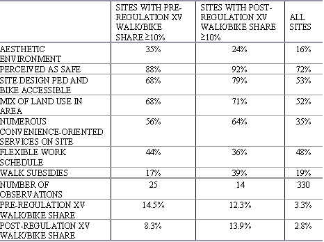
Cambridge Systematics (1994) investigated how transportation demand management (TDM) programs interact with land use and urban design characteristics in influencing mode choice. The study considers 330 southern California employers before and after implementation of Southern California Regulation XV Employee Trip Reduction Ordinance. Their findings support the idea that certain factors compound one another. For example, a site with good pedestrian accessibility that offered financial incentives to decrease single occupancy driving had a 5.5% decrease in single occupancy commuting. Non-accessible sites that offered incentives had a 4.4% decrease, and the difference in single occupancy commuting rates between sites that had both compared to those that had neither, was 5.9%. Financial incentives significantly compounded the impacts of most of the land use and urban design features considered. Table three has some of their findings on the impact of land use and urban design characteristics on walk/bike mode shares. Their data is aggregate and does not follow changes at any given site.
TABLE 3 “CHARACTERISTICS OF SITES WITH A HIGH WALK OR BICYCLE MODE SHARE”, FROM CAMBRIDGE SYSTEMATICS, 1994
The Cambridge Systematics study, like others, found that how easy it is to drive has a significant influence on mode choice. Changes in monetary costs and convenience (congestion and parking) of driving will impact the choice to walk. Employers with high rates of pedestrians and cyclists were 12% less likely than the average to offer flexible work schedules: avoiding the peak commute congestion is a powerful incentive to walk or bike. Their findings also suggest that sites with high bike/walk modal shares were likely to have needed services nearby, such as dry cleaners, day care, post office, and restaurants, and to have work sites and nearby services with pedestrian accessible design. Overall they found that as employers implement programs to encourage carpooling and transit use, walk/bike modal share decreases. Other TDM studies have also found the price and availability of parking to significantly impact travel behavior. (Meyer, 1999, Willson, 1995)
7. Importance of pedestrian accessibility
Pedestrian access may not decrease VMT but has other benefits, like choice and social capital
"Many uses that serve residents and add interest and vitality to traditional shopping areas also attract a high share of non-residents, mostly by car... benefits will stem more from convenience and choice than from trip reduction per se." (Steiner, 1996)
Person (2001) surveyed middle-class residents in the Portland area and found that "residents with a positive perception of their local pedestrian environment were more likely to walk in their neighborhood, engage in neighboring behavior, and become attached to their neighborhood."
Hess et al. observed that in locations with poor pedestrian accessibility, the demographics of pedestrians were different than those of the community at large. Disproportionately, these people were non-white and minors. When walking facilities are inadequate it is principally those with no other options who walk. It is important to think about the implications of ignoring their needs.
Cervero (2001) notes that access to BART stations is by car for 80% of riders, and that by reducing such trips we can reduce cold starts, and thereby impact air quality. "Drive-alone access trips to rail stations, regardless of how short they are, emit levels of pollutants that are not too much below those of the typical 10-mile solo commute."
Ewing (1993) argues for a new way of evaluating our transportation-land use system. LOS measures primarily consider speed, and he suggests that other relevant factors include personal mobility, accessibility, livability and sustainability. "...[L]ess emphasis should be placed on how fast vehicles move and more on how well people are accommodated."
In summary, arguments have been made in support of pedestrian accessibility, such as choice, social capital, equity and air quality. A rethinking of how we evaluate the system would recognize accessibility as inherently valuable.
8. Conclusion
Choice is the essence of accessibility
Why provide for pedestrian access? To afford choice. Choice is the essence of accessibility.
Some charge that if walking rates are indeed higher in pedestrian-friendly places, it is only because of self-selection, and not because site design can impact behavior. Levine (1995) responds that this is a spurious argument. If people are self-selecting such places, that shows we have people who would like to live in pedestrian-friendly environments, and we should give them the option to do so. Handy (1996) found that there is a suppressed demand for pedestrian access. "Many households cannot find housing options that simultaneously meet their primary locational needs, such as quality schools and investment potential, and provide an inviting, safe, and comfortable environment for walking to commercial areas and other destinations."
A mutually reinforcing cycle of land use, urban design and mode choice which all cater to car use, can leave planners feeling impotent and developers unwilling to experiment. Handy (1993b) labels this the "self-destructive cycle of dependence". She offers a model to explain the mechanism of this cycle, and an analysis of why it is a problem. She explains our arrival at this point by the destruction of retail hierarchy, and the creation of network hierarchy, both products of the automobile era. When it is possible for retail stores to draw customers from a wide geographic area, there is an economic incentive to build large stores, built to cater to car access. Fewer (larger) stores means that fewer people live within walking distance. The hierarchy of streets is a result of a desire to protect residential areas from the detriments of cars. This results in a separation of safe pedestrian areas from the streets that go somewhere (and separation of residential and commercial land use.) The resulting large arterials with concentrated vehicle use and mammoth intersections are a terrible pedestrian environment, particularly for children and the elderly. Because routes aren't always direct, effective distances are raised. Freeways made it easier to get to a regional center than to a local center or to the CBD, thus spurring the destruction of the retail hierarchy.
FIGURE 1 "THE CYCLE OF DEPENDENCE-THE CYCLE OF DESTRUCTION" FROM HANDY, 1993b
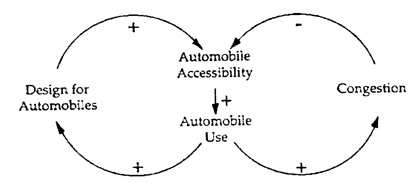
The cycle is unsustainable because it leaves our accessibility vulnerable to congestion, and our auto travel has already begun to exceed the transportation system's capacity. The auto afforded us more choice, hence its popularity. But in catering to it exclusively, we lost some of our options along the way, and now our dependence, which is locked into our built environment, is poised to actually reduce accessibility.
As Handy tackles the question of whether this cycle can be broken, she is not optimistic. Barriers include "risk aversion of developers, the realities of retail economics, and the entrenched practices of planners." Solutions offered involve considering land use and transportation together, and include smaller centers, smaller markets, direct routes and pedestrian friendly design. She recognizes the current neotraditional movement's attempt to implement these ideas but wonders if it is too late. This remains an open question, but if demand for the automobile could play such an important role in determining urban form in the 20th century, perhaps we shouldn't underestimate the role that the burgeoning demand for increased choice might bring.
9. Summary
The three main components of pedestrian accessibility are land use patterns, network, and site design. Accessibility can be measured by evaluation of one or more of its components, or by surveying the perceptions of users. Jurisdictional issues, developer risk-aversion, and durability of the built environment are key implementation hurdles. Successful implementation involves addressing the first two, supportive codes and zoning, persistent advocates, using visual aides, and a multi-faceted approach. Accessible places have more pedestrians, though it is not clear whether pedestrian accessibility can impact VMT. When a place is accessible to pedestrians, users have more transportation options.
CBD central business district
DOT department of transportation
FHWA federal highway administration
GIS geographic information system
LOS level of service
LUTRAQ making the land use, transportation, air quality connection
MPO metropolitan planning organization
NHTSA national highway traffic safety administration
PEF pedestrian environment factor
TAZ traffic analysis zone
TDM transportation demand management
TOD transit-oriented development
VMT vehicle miles traveled
Arambula, D., Lecture on Transit-Oriented Development, Portland State University, February 5, 2002.
Aultman-Hall, L., Roorda, M., and Baetz, B., "Using GIS for Evaluation of Neighborhood Pedestrian Accessibility", Journal of Urban Planning and Development 123(1) 1997, pp 10-17.
Beimorn, E., Rabinowitz, H., Lindquist, P., and Opper, D., "Market-Based Approach to Transit Facility Design", Transportation Research Record 1266, 1990, pp 163-172.
Burden, D., Building Communities with Transportation, Distinguished Lecture Presentation, Transportation Research Board, Washington, DC, 2001.
Cambridge Systematics The Effects of Land Use and Travel Demand Management Strategies on Community Behavior, USDOT, 1994.
Cervero, R., "Walk-and-Ride: Factors Influencing Pedestrian Access to Transit", Journal of Public Transportation 3(4) 2001, pp 1-24.
Cervero, R., and Gorham, R., "Commuting in Transit Versus Automobile Neighborhoods", Journal of the American Planning Association, 61(2) 1995, pp 210-225.
Cervero, R., Transit-Supportive Development in the United States: Experiences and Prospects, Federal Transit administration, Washington, DC, 1993.
City of Portland, Office of Transportation, Portland Pedestrian Design Guide, 1998.
Egan, T., "Sprawl-Weary Los Angeles Builds Up and In", New York Times, March 10, 2002
Ewing, R., "Transportation Service Standards-As If People Matter", Transportation Research Record 1400, 1993, pp10-17.
Ewing, R., Transportation and Land Use Innovations, Planners Press, Chicago, 1997.
Gehl, J., (Koch, J., translator) Life Between Buildings: Using Public Space, Van Nostrand Reinhold, New York, 1987.
Godfrey, D., and Mazzella, T., Success in Redesigning Main Streets for Pedestrians, City of Kirkland, (undated) Handy, S., "Regional Versus Local Accessibility: Implications for Nonwork Travel", Transportation Research Record 1400, 1993a, pp 58-66
Handy, S., "A Cycle of Dependence: Automobiles, Accessibility, and the Evolution of the Transportation and Retail Hierarchies", Berkeley Planning Journal v.8, 1993b, pp 21-43.
Handy, S., "Urban Form and Pedestrian Choices: Study of Austin Neighborhoods", Transportation Research Record 1552, 1996, pp135-144.
Handy, S., and Clifton, K., Evaluating Neighborhood Accessibility: Issues and Methods Using Geographic Information Systems, Center for Transportation Research, University of Texas, Austin, 2000.
Hess, P., Moudon, A., Snyder, M., Stanilov, K., "Site Design and Pedestrian Travel", Transportation Research Record 1674, 1999, pp. 9-19.
Highway Saffety Research Center, Pedestrian Facilities Users Guide- Providing Safety and Mobility, Pub. No FHWA-RD-01-102, FHWA, 2002.
Khisty, C., "Evaluation of Pedestrian Facilities: Beyond the Level-of-Service Concept", Transportation Research Record 1438, 1994, pp 45-50.
Koropeski, A., Loane, G., and Gouch, J., "Toronto-Making Room for All Modes", ITE Journal 68(6) 1998, pp 42-46.
Levine, J., "Access to Choice", Access Fall 1995, pp16-19.
Lutin, J., and Benz G., "Key Issues in Light Rail Transit Station Planning and Design", Transportation Research Record 1361, 1992, pp 14-23.
Lynch, K. and Hack G., Site Planning, 3rd ed. MIT Press, Cambridge, MA, 1984.
McLeod, D., Multimodal Arterial Level of Service, Florida Department of Transportation, 2000. Meyer, M., "Demand Management as an Element of Transportation Poilicy: Using Carrots and Sticks to Influence Travel Behavior", Transportation Research Part A (33), 1999, pp575-599.
Miller, J., Bigelow, J., and Garber, N., "Calibrating Pedestrian Level-of-Service Metrics with 3-D Visualization", Transportation Research Record 1705, 2000, pp 9-15.
Moudon, A., Targeting Pedestrian Infrastructure Improvements: A Methodology to Assist Providers in Identifying Suburban Locations with Potential Increases in Pedestrian Travel, Washington State Transportation Center, report no WA-RD 519.1, Seattle, 2001.
National Highway Traffic Safety Administration, How Walkable is Your Community, US DOT, Ocken, R., Improving Pedestrian Access to Transit: City of Gresham’s Ped-to-MAX Program. Sixth National Conference on Transportation Planning for Small and Medium-Sized Communities, Spokane, Washington, 1999. Oregon Department of Transportation, Oregon Bicycle and Pedestrian Plan, Salem, OR, 1995.
Owen, W, The Accessible City, The Brookings Institution, Washington DC, 1972.
Parsons Brinckerhoff Quade and Douglas, Inc. Making the Land Use Transportation Air Quality Connection, The Pedestrian Environment: Volume 4A, 1000 Friends of Oregon, 1993. Person, H., Local Accessibility, Pedestrian Travel, Neighboring and Community Sentiment in Middle Class Neighborhoods, Dissertation, Portland State University, 2001.
Robinson, F., Edwards, J., Ohrn, C., "Strategies for Increasing Levels of Walking and Bicycling for Utilitarian Purposes", Transportation Research Record 743, 1980, pp 38-48.
Ronkin, M., (ODOT pedestrian and bicycle coordinator), Transportation Seminar, Portland State University, February 8, 2002
Rosenbloom, S., "The Transportation Disadvantaged", in Gray, G. and Hoel, L, (eds), Public Transportation 2nd ed., Prentice Hall: Englewood Cliffs, NJ, 1992, pp 583-615.
Steiner, R., Traditional Neighborhood Shopping Districts: Patterns of Use and Modes of Access, Dissertation, UC Berkeley, 1996.
Surface Transportation Policy Project, "Ped Sheds", Progress, 9(3), 1999, pp 8-9.
Untermann, R., Accommodating the Pedestrian : Adapting Towns and Neighborhoods for Walking and Bicycling, Van Nostrand Reinhold, New York, 1984.
Walkable Communities Inc., Walkable Audit, 2001 Willson, R. "Suburban Parking Requirements", Journal of the American Planning Association, 61(1), 1995, pp 65-81.